Digital information instead of analogue boards: Explore the Geopark interactively
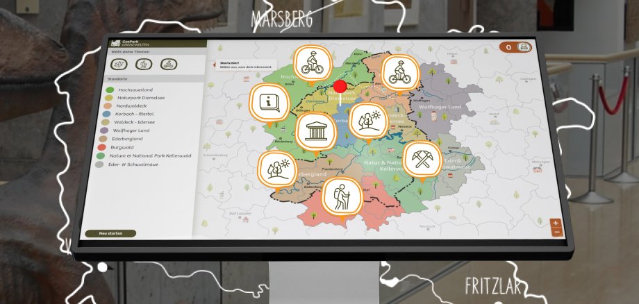
What regions are there in the GrenzWelten National Geopark? What are the geological features in the Ederbergland? Where exactly in the forest near Heimarshausen can I find the Riesenstein? Why is the Korbacher Spalte so unique? And how can I hike the Dohlenfelsen from Geismar on a circular route? The Geopark's new interactive information system provides answers to all these questions and many more. Thanks to special software, interested visitors can now find out what they want to know about the GrenzWelten not only by reading classic explanatory panels. They can also call up the individual thematic fields via a touchscreen and switch effortlessly between the different subsections.
The development of the software for the interactive information cost the Geopark something, says GrenzWelten director Kim Peis. Of the 15,000 euros, the European Union contributed 8,000 euros from a regional development funding pot, arranged by the village and regional development department of the Waldeck-Frankenberg district. Particularly attractive for active "border walkers" of all ages: the selected activities can be saved in a digital hiking basket and converted into an individual QR code. This can be transferred to a smartphone and easily carried in a (trouser) pocket on a hiking, cycling or car tour to the selected destinations.
So far, the new Geopark software has only been installed in media stations in the Wolfgang Bonhage Museum and Tourist Information in Korbach as well as in the Haus Hövener Museum in Brilon, but will be made available free of charge to all Geofoyers, museums and tourist information offices in the GrenzWelten. Only the technology (PC and media station) must be supplemented by the information points. For further information, please contact the Geopark project office on tel. 05631 954-512 or e-mail geopark@lkwafkb.de.