Experience nature and discover stories:
GeoPath opened
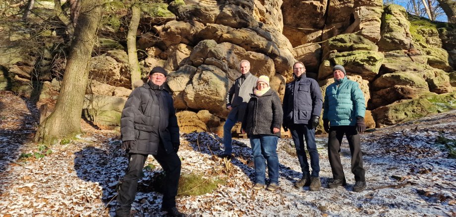
Experience unspoilt nature over 5.8 kilometres and make historical and geological discoveries at the same time: This is now possible on the new GeoPath "Unteres Wattertal" near Lütersheim in Volkmarsen. Today, District Administrator Jürgen van der Horst, Hendrik Vahle, Mayor of Volkmarsen, Hartmut Fischer and Hans-Georg Fischer, Lütersheim local councillors, and Silke Tielke, Geopark GrenzWelten project office at the Environment and Climate Protection Department, opened the GeoPath near Volkmarsen. All interested parties are cordially invited to explore the trail on their own.
Around 245 million years old sandstone runs through the Watter valley near Lütersheim in Volkmarsen. But how exactly was red sandstone actually formed and what secret does the Hollenkammer harbour? This and much more can be discovered on the GeoPath. In addition to the Hollenkammer, visitors can also inspect four other natural monuments. "The Hollenkammer, the Tentenberg, the Huckerhöhle and the Wattertal are all naturally formed landscape elements that have been placed under nature conservation and can now be visited independently along the trail," explained District Administrator Jürgen van der Horst. "In addition to the geological features, sagas and legends have also been passed down from this area. It could even be that there was a pagan cult site in this area," added Silke Tielke from the GrenzWelten Geopark.
The idea for this trail was put forward by the Lütersheim local community to those responsible at the GrenzWelten Geopark. However, the realisation was not quite so simple. "The different interests of the various land leaseholders were decisive in the realisation and had to be taken into account. In order for this to succeed, volunteers, the Lower Nature Conservation Authority in the area of nature conservation and the GrenzWelten Geopark, the town of Volkmarsen and private companies pulled together and put together a wonderful project that invites children and adults on a journey into nature," explained the district administrator.
The project was financed by the district of Waldeck-Frankenberg and the town of Volkmarsen. Mayor Hendrik Vahle: "The newly created GeoPath "Unteres Wattertal" has always been a popular trail, which has now been further enhanced by the comprehensive information on both the history of the earth and the local history of Volkmarsen and Lütersheim, so that supra-regional hikers can also discover the beauty of our region and learn something in the process. It is no coincidence that this trail was chosen as a GeoPath, as the Hollenkammer, for example, is the most popular "attraction" at the motorhome harbour at Kugelsburg. My thanks go to the local council and the Lütersheim local community, the Volkmarser construction and maintenance company, but also the regional companies for realising this project."
With a length of around 6 kilometres and a maximum ascent of 90 metres, the
GeoPath is ideal for a nice Sunday outing with the whole family. Further information about the trail and other offers from the GrenzWelten Geopark can be found on the GrenzWelten Geopark website at www.geopark-grenzwelten.de.
Caption: (from left to right) Head of the village Hartmut Fischer, District Administrator Jürgen van der Horst, Silke Tielke from the Geopark, Mayor Hendrik Vahle and Deputy Head of the village Hans-Georg Fischer in front of the hollow chamber on the new GeoPath near Lütersheim. Photo: District of Waldeck-Frankenberg
Keywords:
Environment and Climate Protection Service Natural Monuments Geopark GrenzWelten